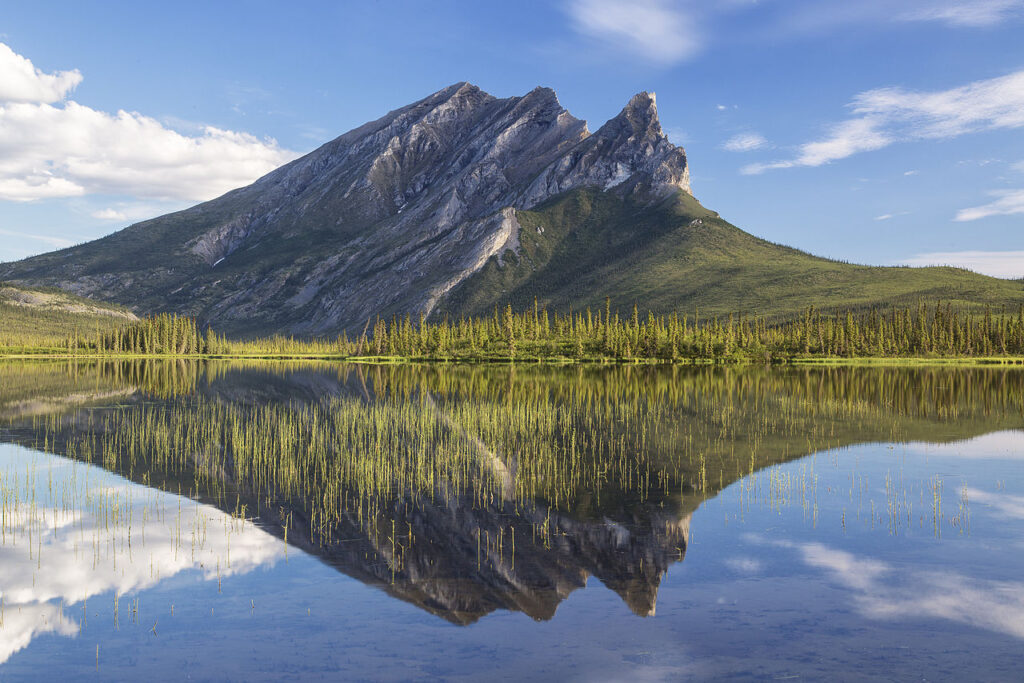
Overview
The Dalton Highway Corridor, also known as the Haul Road, is a 414-mile stretch of rugged road that connects Fairbanks to Prudhoe Bay in northern Alaska. This remote and scenic route passes through some of the most breathtaking landscapes in the state, including the Brooks Range, the Arctic National Wildlife Refuge, and the Gates of the Arctic National Park. As an expert Alaska outdoor guide, I can attest that the Dalton Highway Corridor is a true adventure seeker’s paradise, offering unparalleled opportunities for hiking, camping, wildlife viewing, and exploring the vast and untouched wilderness of Alaska.
What makes the Dalton Highway Corridor special is its unique combination of stunning natural beauty, rich cultural heritage, and extreme remoteness. The road itself is a feat of engineering, built in the 1970s to support the construction of the Trans-Alaska Pipeline. Today, it remains one of the most challenging and rewarding drives in the world, with steep grades, rocky terrain, and unpredictable weather conditions. For those who are willing to take on the challenge, the Dalton Highway Corridor offers an unforgettable experience that will leave you in awe of Alaska’s vast and unspoiled wilderness.
Getting There & Access
To access the Dalton Highway Corridor, you can start in Fairbanks, which is located at GPS coordinates 64.8433° N, 147.7233° W. From Fairbanks, take the Steese Highway (AK-2) north to the town of Fox, then turn left onto the Elliot Highway (AK-2) and continue north to the intersection with the Dalton Highway (AK-11). The Dalton Highway begins at GPS coordinates 65.6333° N, 149.0667° W and stretches north to Prudhoe Bay, located at GPS coordinates 70.2667° N, 148.3167° W.
There are several transportation options available, including driving your own vehicle, taking a shuttle or tour bus, or flying into one of the several small airports along the route. Keep in mind that the road is narrow and rough, and driving conditions can be hazardous, especially during the winter months. It’s essential to have a reliable vehicle, a good map, and a solid understanding of the route and its challenges before embarking on your journey.
- Distance from Fairbanks to Prudhoe Bay: 414 miles (666 km)
- Driving time: 10-12 hours, depending on road conditions and traffic
- GPS coordinates: 64.8433° N, 147.7233° W (Fairbanks) to 70.2667° N, 148.3167° W (Prudhoe Bay)
What to Expect
The Dalton Highway Corridor is a vast and diverse region, with a wide range of landscapes, terrain, and scenery. As you drive north, you’ll pass through boreal forests, cross rivers and streams, and climb steep mountain passes. The road winds its way through the Brooks Range, offering breathtaking views of the surrounding mountains and valleys. You’ll also have the opportunity to see a variety of wildlife, including caribou, moose, bears, and birds of prey.
Terrain and Scenery
The terrain along the Dalton Highway Corridor is varied and challenging, with steep grades, rocky terrain, and unpredictable weather conditions. The road is narrow and winding, with few guardrails and limited visibility in some areas. However, the scenery is stunning, with towering mountains, sparkling lakes, and vast expanses of tundra and wilderness. Be sure to stop at the many scenic overlooks and pull-outs along the way to take in the views and snap photos.
Some of the highlights of the Dalton Highway Corridor include:
- The Atigun Pass, which offers breathtaking views of the surrounding mountains and valleys
- The Brooks Range, which stretches for over 600 miles and offers stunning scenery and hiking opportunities
- The Arctic National Wildlife Refuge, which is home to a wide variety of wildlife, including caribou, bears, and birds of prey
- The Gates of the Arctic National Park, which offers unparalleled opportunities for hiking, camping, and exploring the wilderness
Best Time to Visit
The best time to visit the Dalton Highway Corridor depends on your preferences and the activities you have planned. The summer months (June to August) offer the best weather, with long days and mild temperatures. However, this is also the busiest time of year, with more tourists and traffic on the road. The spring (April to May) and fall (September to October) offer fewer crowds and more comfortable temperatures, but the weather can be unpredictable and the road conditions may be rough. The winter months (November to March) are the most challenging, with extreme cold, short days, and hazardous road conditions.
Keep in mind that the daylight hours vary greatly depending on the time of year. In the summer, the sun can stay up for 24 hours, while in the winter, it may be dark for up to 20 hours. Be sure to plan your itinerary accordingly and bring a good map, compass, and headlamp to navigate the road and surrounding terrain.
- Summer (June to August): 20-24 hours of daylight, mild temperatures (40-60°F)
- Spring (April to May): 18-20 hours of daylight, cooler temperatures (20-40°F)
- Fall (September to October): 12-18 hours of daylight, cooler temperatures (20-40°F)
- Winter (November to March): 0-12 hours of daylight, extreme cold (-20 to -50°F)
Essential Gear & Preparation
When traveling the Dalton Highway Corridor, it’s essential to be well-prepared with the right gear and equipment. This includes:
- A reliable vehicle, preferably with four-wheel drive and high clearance
- A good map, compass, and GPS device or app
- Food, water, and snacks for at least 2-3 days
- First aid kit and emergency supplies, including a satellite phone or two-way radio
- Camping gear, including a tent, sleeping bag, and stove
- Warm clothing, including a parka, gloves, and hat
- Binoculars and a camera to capture the stunning scenery and wildlife
It’s also essential to have a solid understanding of the route and its challenges, including the road conditions, weather forecast, and potential hazards such as bears, moose, and avalanches. Be sure to check the road conditions and weather forecast before embarking on your journey and plan your itinerary accordingly.
Wildlife & Safety
The Dalton Highway Corridor is home to a wide variety of wildlife, including bears, moose, caribou, and birds of prey. When traveling through this region, it’s essential to be aware of your surroundings and take necessary precautions to avoid encounters with wildlife. This includes:
- Keeping a safe distance from wildlife, at least 100 yards
- Not feeding or approaching wildlife, including bears and moose
- Making noise while hiking or walking to avoid surprising animals
- Carrying bear spray or other deterrents, such as flares or whistles
- Being aware of your surroundings, including the terrain, weather, and road conditions
In addition to wildlife, there are other hazards to be aware of, including extreme weather conditions, steep terrain, and limited access to medical care. Be sure to bring a first aid kit and emergency supplies, including a satellite phone or two-way radio, and know how to use them in case of an emergency.
History & Background
The Dalton Highway Corridor has a rich and fascinating history, dating back thousands of years to the indigenous peoples who first inhabited the region. The road itself was built in the 1970s to support the construction of the Trans-Alaska Pipeline, which stretches from Prudhoe Bay to Valdez. Today, the road remains an essential transportation route for the oil and gas industry, as well as a popular tourist destination for adventure seekers and nature lovers.
The region is also home to a number of significant historical and cultural sites, including the Brooks Range, which was formed over 2 billion years ago, and the Arctic National Wildlife Refuge, which is one of the largest and most pristine wilderness areas in the United States. Be sure to stop at the many interpretive signs and visitor centers along the way to learn more about the history and culture of the region.
Tips from Locals
As an expert Alaska outdoor guide, I’ve had the opportunity to explore the Dalton Highway Corridor numerous times and have learned a few tips and tricks from locals and fellow travelers. Here are a few insider secrets to help you make the most of your journey:
- Be sure to fill up on gas whenever possible, as services can be limited in this remote region
- Bring a good map and compass, as well as a GPS device or app, to navigate the road and surrounding terrain
- Keep a safe distance from wildlife, including bears and moose, and be aware of your surroundings at all times
- Be prepared for extreme weather conditions, including cold temperatures, wind, and precipitation
- Don’t be afraid to ask for help or advice from locals, including park rangers, guides, and other travelers
Some of the hidden gems of the Dalton Highway Corridor include:
- The Galbraith Lake Campground, which offers stunning views of the surrounding mountains and lakes
- The Atigun Pass, which offers breathtaking views of the Brooks Range and the Arctic National Wildlife Refuge
- The Toolik Field Station, which offers insights into the science and research being conducted in the region
Nearby Attractions
There are a number of nearby attractions and activities to explore in the Dalton Highway Corridor, including:
- Hiking and backpacking in the Brooks Range and the Arctic National Wildlife Refuge
- Wildlife viewing, including bears, moose, caribou, and birds of prey
- Fishing and boating on the many lakes and rivers in the region
- Visiting the Prudhoe Bay Oil Field, which offers insights into the oil and gas industry
- Exploring the Gates of the Arctic National Park, which offers unparalleled opportunities for hiking, camping, and exploring the wilderness
Some of the other nearby towns and cities include:
- Fairbanks, which offers a range of amenities, including restaurants, hotels, and outdoor gear stores
- Coldfoot, which offers basic services, including gas, food, and lodging
- Wiseman, which offers a glimpse into the region’s rich history and culture
Planning Resources
When planning your trip to the Dalton Highway Corridor, be sure to check the following resources for up-to-date information and advice:
- The Alaska Department of Transportation, which offers information on road conditions and construction
- The Alaska Public Lands Information Center, which offers insights into the region’s history, culture, and natural resources
- The National Park Service, which offers information on the Gates of the Arctic National Park and the Arctic National Wildlife Refuge
- The Alaska Travel Industry Association, which offers tips and advice on traveling in Alaska
Some of the useful links and contact information include:
- Alaska Department of Transportation
- Alaska Public Lands Information Center
- National Park Service
- Alaska Travel Industry Association
Remember to always be prepared, bring the right gear and equipment, and respect the region’s unique culture and environment. With the right planning and preparation, your journey along the Dalton Highway Corridor is sure to be an unforgettable adventure.