Trail Overview
The Byron Glacier Trail is a stunning and accessible hiking route located in the Chugach National Forest, approximately 49 miles southeast of Anchorage, Alaska. This trail is special because it offers breathtaking views of the surrounding mountains, valleys, and glaciers, making it a must-visit destination for outdoor enthusiasts. The trail’s key highlights include its unique glacier features, abundant wildlife, and picturesque landscapes. Hikers love this trail for its moderate difficulty, well-maintained path, and the opportunity to explore a glacier up close.
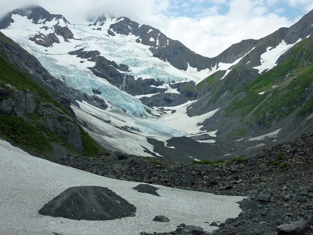
One of the most distinctive features of the Byron Glacier Trail is its proximity to the glacier itself. The trail takes hikers through a scenic valley surrounded by towering mountains, eventually leading to the toe of the glacier. Along the way, hikers can observe the glacier’s unique features, such as its moraines, seracs, and crevasses. The trail also offers abundant opportunities to spot wildlife, including bears, moose, and Dall sheep.
Trail Stats at a Glance
- Distance: 3.3 miles round-trip
- Elevation Gain: 700 feet
- Difficulty: Moderate
- Estimated Time: 2-4 hours
- Trail Type: Out-and-back
- Dog-Friendly?: Yes, but please keep dogs on a leash
- Kid-Friendly?: Yes, but please supervise children closely due to potential hazards such as steep drop-offs and fast-moving water
Getting There
To access the Byron Glacier Trail, drive from Anchorage to the town of Girdwood, which is approximately 37 miles southeast of Anchorage. From Girdwood, take the Seward Highway (AK-1) south for 12 miles, then turn left onto the Portage Glacier Road (also known as the Whittier Access Road). Continue on this road for 5 miles, then turn left onto the Byron Glacier Trailhead parking lot. The GPS coordinates for the trailhead are 60.7833° N, 148.8667° W.
The parking lot is well-marked and has ample space for vehicles. There is a day-use fee of $5 per vehicle, which can be paid at the self-service kiosk near the trailhead. The trailhead facilities include a restroom, picnic tables, and a informational kiosk with trail maps and brochures.
Detailed Trail Description
The Byron Glacier Trail begins at the trailhead parking lot and immediately enters a scenic valley surrounded by towering mountains. The trail is well-maintained and easy to follow, with a gentle incline that winds its way through the valley. At approximately 0.5 miles from the trailhead, the trail crosses a small creek, which can be rocky and slippery. Hikers should exercise caution when crossing this creek, especially during periods of high water.
As the trail continues, it enters a forested area with dense vegetation and abundant wildlife. Hikers may spot bears, moose, and Dall sheep in this area, so it’s essential to make noise while hiking and stay alert. At approximately 1.5 miles from the trailhead, the trail emerges from the forest and enters a scenic meadow with stunning views of the surrounding mountains. This is an excellent spot to take a break and enjoy the scenery.
The trail then continues to climb, with a series of switchbacks that lead to the toe of the glacier. The views from this point are breathtaking, with the glacier stretching out before you like a vast, frozen landscape. Hikers can explore the glacier’s moraines, seracs, and crevasses, but should exercise extreme caution due to the potential hazards of glacier travel.
At approximately 2.5 miles from the trailhead, the trail reaches its terminus at the toe of the glacier. From this point, hikers can return the way they came, or explore the glacier further. However, it’s essential to note that glacier travel can be hazardous, and hikers should be aware of the risks and take necessary precautions.
The return journey follows the same route as the ascent, with hikers retracing their steps through the scenic valley and forested area. The total distance for the round-trip hike is approximately 3.3 miles, with an elevation gain of 700 feet.
Best Time to Hike
The best time to hike the Byron Glacier Trail depends on your preferences and the activities you want to do. Here’s a month-by-month breakdown:
- June: The trail is usually snow-free, and the wildflowers are in bloom. However, the days are long, and the sun can be intense.
- July: This is the peak tourist season, and the trail can be busy. However, the weather is usually warm and sunny, and the wildflowers are still in bloom.
- August: The days start getting shorter, and the weather can be cooler. However, the trail is still snow-free, and the scenery is stunning.
- September: The fall colors are starting to appear, and the trail is less crowded. However, the weather can be cooler and more unpredictable.
- October: The trail can be snowy, and the weather is usually cooler. However, the scenery is still stunning, and the trail is less crowded.
- Winter: The trail is usually snow-covered, and the weather can be harsh. However, the scenery is still stunning, and the trail can be accessed with snowshoes or cross-country skis.
What to Bring
When hiking the Byron Glacier Trail, it’s essential to bring the right gear and supplies. Here are the Ten Essentials adapted for Alaska:
- Navigation: Map, compass, and GPS device or app
- Hydration: Water bottle or hydration bladder, and water treatment tablets or filter
- Nutrition: Energy-rich snacks, and a lunch or dinner if you plan to spend the day on the trail
- First Aid: First aid kit, and any personal medications
- Shelter: Emergency shelter, such as a lightweight tent or bivy sack
- Warmth: Extra layers, including a hat, gloves, and warm socks
- Lighting: Headlamp or flashlight, and extra batteries
- Fire: Fire starter, such as a match or lighter, and tinder
- Repair Kit: Multi-tool or pocket knife, and duct tape
- Communication: Cell phone, and a two-way radio or satellite phone if you’re hiking in a remote area
In addition to the Ten Essentials, hikers should also bring bear spray, trekking poles, and a camera to capture the stunning scenery.
Wildlife & Safety
The Byron Glacier Trail is home to a variety of wildlife, including bears, moose, and Dall sheep. Hikers should be aware of their surroundings and take necessary precautions to avoid encounters with wildlife. Here are some tips:
- Make noise while hiking to avoid surprising bears or other wildlife
- Stay in groups and avoid hiking alone
- Keep a clean campsite, and store food and trash properly
- Be aware of your surroundings, and watch for signs of wildlife such as tracks or scat
In addition to wildlife, hikers should also be aware of other hazards such as steep drop-offs, fast-moving water, and inclement weather. It’s essential to check the weather forecast before heading out, and to be prepared for changing conditions.
Photography Tips
The Byron Glacier Trail offers stunning photography opportunities, with breathtaking views of the surrounding mountains, valleys, and glaciers. Here are some tips for capturing the best shots:
- Bring a wide-angle lens to capture the vast landscapes
- Use a polarizing filter to reduce glare and enhance colors
- Shoot during the golden hour, when the light is soft and warm
- Look for interesting compositions, such as leading lines or framing elements
Some of the best viewpoints on the trail include the scenic meadow at approximately 1.5 miles from the trailhead, and the toe of the glacier at approximately 2.5 miles from the trailhead. These viewpoints offer stunning views of the surrounding mountains and glaciers, and are perfect for capturing iconic shots.
History & Background
The Byron Glacier Trail has a rich history and background, dating back to the gold rush era. The trail was originally used by miners and prospectors, who would hike to the glacier to access the surrounding mountains and valleys. The trail was also used by indigenous peoples, who would hunt and gather in the area.
The trail was named after the Byron Glacier, which was named after a prospector who worked in the area. The glacier itself is a unique feature of the trail, with its moraines, seracs, and crevasses. The trail was constructed in the 1960s, as part of a larger effort to develop the Chugach National Forest for recreational use.
Today, the Byron Glacier Trail is one of the most popular hiking trails in the Chugach National Forest, attracting thousands of visitors each year. The trail is managed by the US Forest Service, which works to maintain the trail and protect the surrounding environment.
Nearby Trails & Campgrounds
The Byron Glacier Trail is part of a larger network of trails and campgrounds in the Chugach National Forest. Some nearby trails and campgrounds include:
- The Portage Glacier Trail, which offers stunning views of the Portage Glacier and surrounding mountains
- The Whittier Trail, which leads to the town of Whittier and offers stunning views of the surrounding fjords and mountains
- The Williwaw Campground, which offers scenic campsites and access to the surrounding trails and wilderness areas
- The Granite Creek Campground, which offers scenic campsites and access to the surrounding trails and wilderness areas
These trails and campgrounds offer a range of recreational opportunities, from hiking and camping to fishing and wildlife viewing. They are perfect for multi-day adventures, and offer a chance to explore the stunning scenery and wildlife of the Chugach National Forest.